Field notes, audio, and film from a changing valley
In the early days of spring, before the first buds of almond trees began to bloom, our village would come alive with the sounds of anticipation.
It was the time of Gangul, a cherished tradition that marked the beginning of the farming season in Kashmir. The sharing of walnuts, a symbol of prosperity, and the sweetened rice, a token of sweetness in life, were blessings bestowed upon the next generation. It was a moment when the community came together, bound by a shared purpose and a collective memory of the seasons that shaped our lives. The rhythmic clatter of wooden ploughs. My father, along with other farmers, would lead their bulls to the fields, guiding them with steady hands and seasoned eyes. This symbolized strength and hope. As they broke the ground, elders would gather the children, distributing walnuts and rice mixed with sugar, a simple yet profound gesture that connected us to the land and to each other. The essence of Gongul is beautifully captured in the words of Sheikh Noor-ud-Din Noorani, also known as Sheikh-ul-Alam or locally known as Nundreish, a revered Sufi saint of Kashmir:
“Yus kari gongul, sui kari kraw”
“He who sows, shall be the one to harvest too.” -Sheikh Noor-ud-Din Noorani (Sheikh-ul-Alam)
Sheikh Noorani’s teachings extended beyond spiritual realms; they were deeply rooted in the realities of daily life. In another of his verses, he reflects on the transformation of tools of war into instruments of cultivation:
“Kartal phetrem ta gearimas Dreati”
“I broke the sword and molded sickles out of it.”
The sword turned sickle was not just a metaphor for peace, but also a call to dignity through cultivation, and a reminder that creation, not destruction, anchors societies. This profound shift from violence to nurturing, from destruction to creation, mirrors the evolution of Kashmir’s agrarian practices.
Historically, the region’s farming communities endured the burdens of begar (forced labor) under feudal systems, where peasants were compelled to work without compensation. This exploitative system fractured the backbone of the Kashmiri peasantry, leading to widespread discontent and eventual reforms. The transition from such oppressive structures to a more equitable system was marked by significant land reforms.
The Land to Tiller Act aimed to abolish the feudal system, granting ownership rights to the actual cultivators. These reforms were not just legal changes. they represented a reclaiming of dignity and autonomy for the farmers, aligning with the spiritual ethos of Sheikh Noorani’s teachings. But as I stand in the fields today, I see a new kind of dispossession unfolding. In the name of development, prime agricultural land, the backbone of Kashmir’s economy—is being systematically sabotaged and swallowed. Orchards that once stood as symbols of prosperity are being uprooted. They are being removed to make way for highways, railways, industrial parks, and military garrisons. Fertile fields that nourished families for centuries are fenced, demarcated, and reclassified, often without the meaningful consent of those who have lived and labored on them.
Through this blog, I try to capture this collision: the voices of farmers watching their land vanish, the memory of customs like Gongul that rooted us (Kashmiris) in the soil, and the stark reality of how political control often begins with the control of land. To speak of Kashmir’s land is to speak of its people, their identity, and their survival.
At the heart of this inquiry lies a haunting question: “Kus kari Gongul?” — Who will sow? This is no longer just a seasonal invocation of fertility, but a question about the future of Kashmir itself.
Farmers’ Voices: In intimate conversations, farmers recount how their orchards, fields, and meadows are acquired, fenced, or demarcated without their consent. Their testimonies reveal not only economic loss but the emotional rupture of being severed from ancestral soil.
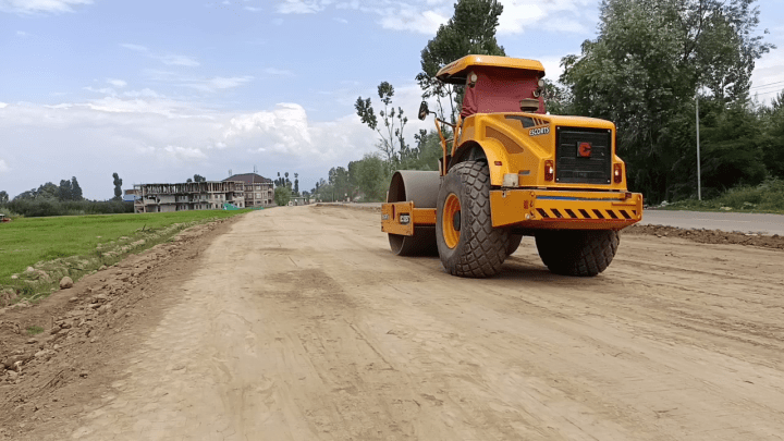
Changing Landscapes: The valley’s physical geography is transforming before our eyes—green orchards replaced by grey highways, wetlands drained for housing colonies, glaciers carved by road-building machines. These visual shifts in the land are not neutral progress; they are evidence of systematic dispossession.
Land Laws (and their violations): The post-2019 legal regime has opened Kashmir’s land to outside ownership, often in direct violation of protections that once safeguarded local farmers. These laws, altered or bypassed, reveal how the machinery of governance itself becomes a tool of displacement.
Surveillance and Restricted Speech: Farmers who resist or raise questions face constant watchfulness—surveys, drones, and census-like exercises that catalog their lives. Freedom to speak, protest, or even publicly mourn the loss of land is tightly restricted, ensuring silence in the face of transformation.
Corporate Expansion: New industrial policies and corporate acquisitions have shifted control of fertile tracts from cultivators to large private players. Agriculture, once a community-driven economy, is being restructured under corporate interests that rarely serve the farmer.
Religious Tourism and Demographic Engineering: Alongside corporate control is the aggressive promotion of Hindu religious tourism projects, often built over fragile ecologies and agricultural spaces. Pilgrimage routes and facilities expand into meadows and forests, turning sacred landscapes into contested zones of identity and control.
Climate Change: Farmers also confront the undeniable signs of climate shifts—cloudbursts, erratic snow, shrinking glaciers, and declining crop yields. These changes exacerbate the precariousness of farming, threatening Kashmir’s agrarian future from within as much as external forces do from without.
Resilient Methodologies: Yet, amid these challenges, resilience endures. Farmers continue to adapt, organize, and resist. Through my work, I engage in workshops on land laws, training in visual evidence collection, and community dialogues aimed at empowering farmers with knowledge and tools to defend their rights. These small acts of resistance—archiving, educating, documenting—are attempts to keep alive the possibility of sowing again.
Thus, the question “Kus kari Gongul?” is both a lament and a call to action. Who will sow, when the land itself is under siege? Who will sow, when fields become highways, orchards become concrete, and glaciers melt into rivers of loss? And yet—who will sow, if not those who refuse to surrender, who still believe that to till the soil is to claim both dignity and survival?
At the crossroads of soil and struggle
Since August 2019, when the Government of India revoked Jammu & Kashmir’s limited autonomy under Article 370, the region was immediately placed under an unprecedented lockdown—marked by a strict curfew, mass detentions, and a total communications blackout that stretched for months. This moment not only dismantled the constitutional framework that had previously offered Kashmir a distinct political status but also ushered in sweeping legal, economic, and administrative changes under direct central rule. Previously, land in J&K was primarily governed by the Jammu and Kashmir Land Acquisition Act, 1934, and a suite of local statutes such as the J&K Alienation of Land Act (1938), the Big Landed Estates Abolition Act (1950), and the J&K Land Grants Act (1960). These historic laws gave “permanent residents” significant protections: only state subjects could own land, and outsiders were barred from purchase or lease. Landmark reforms such as the Big Landed Estates Abolition Act redistributed large holdings from landlords to local tillers, restricting ownership and supporting agrarian communities. Together, Articles 35A and 370 shielded local populations from external land grab pressures and large-scale demographic change, forming the legal backbone for the region’s agrarian reforms and land redistribution from large landlords to local tillers post-1947.
Land, Infrastructure, and the Architecture of Dispossession
In recent years, Jammu & Kashmir has witnessed an unprecedented wave of land acquisition by the Government of India under the banner of infrastructure and development. The construction of 30 new satellite townships alone accounts for nearly 118,000 kanals (14,750 acres) across the valley, transforming vast stretches of agricultural and horticultural land into urban clusters. The much-publicized Jammu Ring Road absorbed another 4,730 kanals (591 acres), reshaping the region’s physical and social landscape. Alongside urban expansion, a parallel drive for industrialization has seen more than 8,600 acres (close to 69,000 kanals) earmarked for new industrial estates, with Kathua district emerging as a hub for large-scale projects and fresh allotments. These urban and industrial initiatives are tightly linked to the semi-Ring Road corridor, cutting through six central Kashmir districts. In Srinagar and Budgam, government notifications have designated 55 revenue villages as “no-construction zones,” freezing farmers’ ability to sell, develop, or even improve their land. While framed officially as “planned urban development,” the reality on the ground reflects large-scale expropriation: in Budgam alone, over 590 acres have already been taken for the Ring Road project, with compensation disputes unresolved. For farming families, this vision of progress translates less into opportunity and more into the slow erosion of their most vital resource—the land that feeds and sustains them.
The MORTH (Ministry of Road Transport and Highways) report frames the Srinagar Ring Road as a strategic mobility project, emphasizing connectivity to “border/strategic areas” such as Baramulla, Uri, Kupwara, Bandipora, and Ganderbal. The language of the report highlights the road’s role in easing congestion and facilitating the movement of heavy machinery—signaling its dual function as both an urban infrastructure project and a logistical corridor for security and military purposes. However, a closer reading reveals the political economy of infrastructure in conflict zones. The alignment traverses 52 villages across five districts (Pulwama, Budgam, Baramulla, Srinagar, and Bandipora)—areas with dense agricultural landholdings and a high dependence on farming. While the state presents the project as serving “inhabitants,” the primary beneficiaries, as implied by the report itself, are defense logistics and freight mobility rather than local communities. For villagers whose land has been acquired, this “greenfield alignment” translates into dispossession and disruption of agrarian livelihoods, often with opaque compensation mechanisms and limited avenues for redress. Railways and highways provide another layer to this dramatic reshaping of Jammu & Kashmir’s land use: projects like the Udhampur-Srinagar-Baramulla Rail Link and other highway expansions together account for at least 5,000 additional kanals (over 625 acres).
Recent data suggests that since August 2019, the cumulative area acquired for highways, military, and institutional development alone surpasses 6,600 kanals, with the total land converted for public projects likely exceeding 140,000 kanals (around 17,500 acres) by 2025. This ongoing and multifaceted spate of acquisitions signals not just rapid development but also a profound transformation in rural livelihoods and the region’s socio-environmental fabric.
The conversion of agricultural land into non-agricultural use is accelerating, undermining not only livelihoods but also food security in the valley.
Further, The Indian government has green-lit a major new infrastructure project: a 300-kilometre, four-lane highway linking Rajouri with Baramulla in north Kashmir, estimated at ₹3,300 crore. Officially designated NH-701A, this highway will trace portions of the existing Mughal Road and then extend as a new corridor, cutting across key areas such as Shopian, Magam, Yousmarg, Doodhpathri, Charar-e-Sharief, Pakherpora, Kellar, and Bafliaz before terminating near Surankote in Poonch. The project falls under the Border Roads Organisation (BRO) and includes consultancies for feasibility, detailed project reports, and construction oversight provided to the Ministry of Road Transport & Highways. Covering terrain in some of the most scenic—and also most agriculturally and culturally sensitive—parts of Kashmir, this road is billed as a much-needed alternative to the congested Jammu-Srinagar highway, with construction expected to begin soon and be completed within two years, followed by a five-year maintenance phase.
The authorities, without respecting even their own laws, denied us fair compensation. What we received were mere peanuts. Left with no land, we tried to resist—but when we objected to vacating, three boys from our village were detained by the local police. All we were asking for was fair compensation under the law. Now we are left to wonder: what will we do, and where will we go?
Railways and highways provide another layer to this dramatic reshaping of Jammu & Kashmir’s land use: projects like the Udhampur-Srinagar-Baramulla Rail Link and other highway expansions together account for at least 5,000 additional kanals (over 625 acres). Recent data suggests that since August 2019, the cumulative area acquired for highways, military, and institutional development alone surpasses 6,600 kanals, with the total land converted for public projects likely exceeding 140,000 kanals (around 17,500 acres) by 2025. This ongoing and multifaceted spate of acquisitions signals not just rapid development but also a profound transformation in rural livelihoods and the region’s socio-environmental fabric. Official records show that Jammu and Kashmir has lost more than 60,000 hectares of agricultural land since 2000. Between 2015–16 and 2022–23 alone, the cultivable area fell from 741,000 hectares to 681,000 hectares, an 8 percent decline. In some districts, the change is irreversible: in Srinagar, farmland has declined by nearly 40 percent over the last two decades, while Kulgam and Pulwama have each lost between 30 and 50 percent of their paddy area.
Each new roof replaces a patch of earth that can no longer breathe or grow. Shaban lives in a village at the foot of Kashmir’s only airport, the Srinagar airport, which is primarily controlled by the Indian defence forces. The airfield stands atop a Karewa, a fertile plateau that once nurtured rich soil and almond orchards before its conversion into an airbase.
Gogoland, Rangreth, Kralpora, Wathoora, Buchroo, Lalgam, Panzan, and Gudsathoo.
The conversion of agricultural land into non-agricultural use is accelerating, undermining not only livelihoods but also food security in the valley. Kashmir now produces only 0.45 million tonnes of rice annually, enough to meet just 35 percent of its domestic demand. The region faces a 38 percent calorie deficit, among the highest in India, and nearly 70 percent of households rely on imported food grains through the Public Distribution System.Where families once prided themselves on feeding the valley from its own soil, today they depend on supply chains stretching far beyond the mountains. 70% of rice consumed in the region is sourced from other Indian states, with most households dependent on Public Distribution System rations. The region currently produces only 30% of its food needs; local self-sufficiency has eroded as commercial returns from land outweigh the priority of growing indigenous foods.
According to the State Nutrition Profile of Jammu & Kashmir published by NITI Aayog, UNICEF, and IIPS (2022), the region faces a 38 percent calorie deficit, with average rural dietary energy intake measured at 1,897 kilocalories per person per day, well below the national rural average of 2,099 kcal. The report links this deficit to reduced local food production, dietary monotony, and growing dependence on imported food grains.

Gulam Nabi Bhat, a farmer in his mid-sixties from Budgam district, walks me through what remains of his fields in Wathoora village, at the base of the Damodar Karewa, the plateau that now hosts the Srinagar airport. The newly built Srinagar Semi Ring Road cuts directly through this landscape. Wathoora alone has lost around 225 kanals of prime farmland to the project. Gulam Nabi stops beside his small patch of surviving land, where, with the help from the horticulture department, he has planted a high-density apple orchard. He tells me he lost eight kanals (one acre) to the road construction. The remaining part of his land now stays waterlogged for months; the road’s elevated embankment blocks the natural flow of water, turning his field into a shallow pool after every rainfall.
Frustrated by years of neglect, Gulam Nabi filed a petition before India’s National Green Tribunal (NGT), challenging the Srinagar Semi Ring Road’s environmental clearances. His case, part of a broader complaint by local residents, argued that the raised embankment of the road had blocked natural water channels, flooding entire stretches of farmland. The Tribunal acknowledged the impact and directed inspections, yet on the ground, little has changed. The drainage remains choked, the crops still drown, and the dust from the road still settles on the leaves of Gulam Nabi’s orchard.
The road took my land once when it was built, he says, and now it’s taking it again, piece by piece, every time it rains

We used to grow mustard, paddy, and vegetables. This part of Budgam has always been known for its fertile soil, perfect for such crops. But over time, with the decline in irrigation and the changes in our geography, people began to see land only in terms of commercial value. We used to grow mustard, paddy, and vegetables. This part of Budgam has always been known for its fertile soil, perfect for such crops. But over time, with the decline in irrigation and the changes in our geography, people began to see land only in terms of commercial value.
Land that once fed our families for generations is now seen as a means to profit. With the commercialisation of agriculture, farmers have shifted to high-density apple orchards, hoping for quick returns; but it’s not the same.
This case is the first of its environmental petitions from Kashmir challenging post-2019 land-use changes on ecological and livelihood grounds. Semi ring road has been classified as a “strategic infrastructure corridor,” hence the project bypassed full EIA scrutiny under Category B exemptions; a legal loophole often used in “linear infrastructure” like highways.Pointing toward the highway and the dust settling on the leaves of his young apple trees, he says,
Look at this pollution – it’s killing what’s left of my farm. Nobody cares. I’ve watched this land change, foot by foot, into concrete: roads, malls, buildings that often stay empty. The land is vanishing fast, and I don’t know what it will look like in the years ahead.
I met Mohammad Afzal, another farmer who owns only a small patch of land now, barely enough to sustain. Most days he works at Gulam Nabi’s orchard, cutting grass to feed his cows.
The aerodrome you see up there,” he points towards the hill, “we had land there once, before it was taken for the airport back in the 1950s. Now, I go there only to look; it’s all fenced, all under the army
Wathoora, just fourteen kilometers from Srinagar’s city center, is emblematic of a larger transformation. Once a quiet farming village, it now sits under the weight of rapid urbanisation, where new housing colonies, shopping complexes, and overlapping road networks steadily consume what was once fertile ground.The farms stay in water by choked irrigation system and the road stands as a wall.
Saqib shares his connection to the land — as farmer, as poet, as witness.
The rapid conversion of agricultural land for roads, railways, commercial property, and housing in Kashmir Valley is accelerating, threatening livelihoods and food security. This shift, driven by development and urbanization, has dramatically reduced areas under staple crops like paddy and increased reliance on imported food grains. Once fertile paddy land is converted for commercial or non-agricultural purposes, a house, a complex, or even a small shop, it is permanently lost to cultivation. Such transformations, as experience and date shows, are irreversible. Several farmers I met during my research spoke of how dramatically the landscape around their villages has changed over the past two decades. The once-continuous stretch of paddy fields has been slowly consumed by houses, shops, and construction sites.
People need land to build homes, says M. Shaban, a farmer from Budgam. The demand for plots has grown over the years. Most families from the villages near Srinagar airport have now spread across what used to be our green paddy fields
This demand, rooted in population growth and aspirations for urban life, is real, yet it comes at the cost of fertile soil that once sustained generations.
The neglect of canals systems
Dr. Bashir Veeri, a sitting MLA of the ruling J&K National Conference from Bijbehara in Anantnag, moves through the villages of his constituency, stopping at road construction sites and meeting residents in remote Scheduled Tribe settlements. We walk together through apple orchards heavy with late summer foliage. He gestures toward a narrow stream cutting across the fields—the Dadi Canal, built during the Dogra rule—its flow shallow, uneven, almost hesitant. From there, he speaks of another canal, far older and once far more consequential: the Nandi Canal. Developed in the fifteenth century under Sultan Zain-ul-Abideen, locally known as Badshah, the canal was built on the encouragement of the Sufi mystic Sheikh-ul-Alam (Nundresh), who urged local farmers to create a system that could sustain their fields and livelihoods. Branching from the Veshov, a tributary of the Jhelum, the Nandi Canal stretched nearly eighteen kilometres and once irrigated around 2,000 hectares of farmland across more than twenty-four villages in Anantnag and Kulgam—an area long known as the rice bowl of Kashmir. With a carrying capacity of 6.64 cubic metres of water per second, it was among the most significant irrigation systems of its time.
Today, the canal stands on the brink of collapse. Its embankments are choked with garbage, its flow weakened by illegal riverbed mining and unplanned concretisation, leaving downstream villages in chronic water shortage. Dr. Muzaffar, an environmental activist, says mining in the Veshov Nallah has drastically reduced water flow, damaging the canal’s natural retention system. “Leakage, overflow, and seepage,” he explains, “show the complete apathy of the irrigation department toward this historic canal that once sustained life here.”
Dr. Veeri shares this frustration.
You cannot execute any developmental or infrastructural project without the consent of the local population, he says. Yet they bypass the law, use force, and compel people to accept compensation for land taken for roads and highways. It is a shameful act of dispossessing; an attack on the soul of this community. And that soul is its agriculture.
Walking along the broken banks of the canal, it becomes clear that the story of water in Kashmir is no longer just about irrigation. It is about control. What once flowed freely through the veins of this land now stumbles under the weight of neglect, bureaucracy, and the machinery of ‘development’. The expanding web of highways across South Kashmir cuts through what was once the valley’s rice belt, altering not just the geography but the circulatory system of its water. Traditional canals that once carried life into the fields now lie clogged with silt and refuse, drowned out by the noise of excavators. Each new ‘upgrade’ erases something older and quieter—systems that worked, even if imperfectly. Canals that fed rice paddies. Karewas that held moisture and grew almonds. Flattened, excavated, built over, sacrificed for the next project report. In the name of progress, networks of survival built by hand, managed through trust, and sustained over centuries are being dismantled piece by piece. The shift is subtle, almost bureaucratic in tone, but visible in every field: from community-managed irrigation to state-managed construction; from water that fed crops to asphalt that feeds an economy of contracts, tenders, and clearances. Beneath it all, farmers stand at the edges of drying canals, watching their crops wilt, uncertain whether the next project will restore water or take what little remains.
Water-sharing in Kashmir was never merely technical; it was social, even sacred. I come from a village that hosts three irrigation canals, each feeding fields across dozens of villages downstream in Budgam. Water meant responsibility. I remember men; young and middle-aged gathering in our local mosque after evening prayers, carrying torches or kerosene lamps, taking turns to guard the flow through the night, ensuring each village received its share in time. There was order in that rhythm, a quiet cooperation that kept the land alive.
Quiet Before the Road:
The consequences of this shift are visible even before construction begins
On my way to Nowgam, a quiet village in Kashmir’s Shopian district, I pulled over to ask a question. Word had spread that a road was being planned through the heart of the village’s apple orchards; orchards that have sustained families for generations. As I rolled down my window, two men leaned in, assuming I was some government official.
I asked whether any demarcation signs had been placed by the National Highways Authority of India, or if construction had begun. Both shook their heads. “No signs, no work yet,” one of them said. Then, almost casually, they added that most landowners had already received compensation a few months earlier.
When I asked if anyone had objected, they exchanged a brief smile.
Who would say no? one of them asked. Even if the project doesn’t serve the community, when the government decides, it decides. It’s safer to stay quiet and accept what’s offered.
A few kilometres ahead, a red concrete demarcation pole stood awkwardly inside an apple orchard. I stopped, slung my camera over my shoulder, and walked in. A man stood nearby, grazing a single sheep—likely for Eid sacrifice.
I asked if I could enter. He nodded.
“Is this your land?”
Another nod.
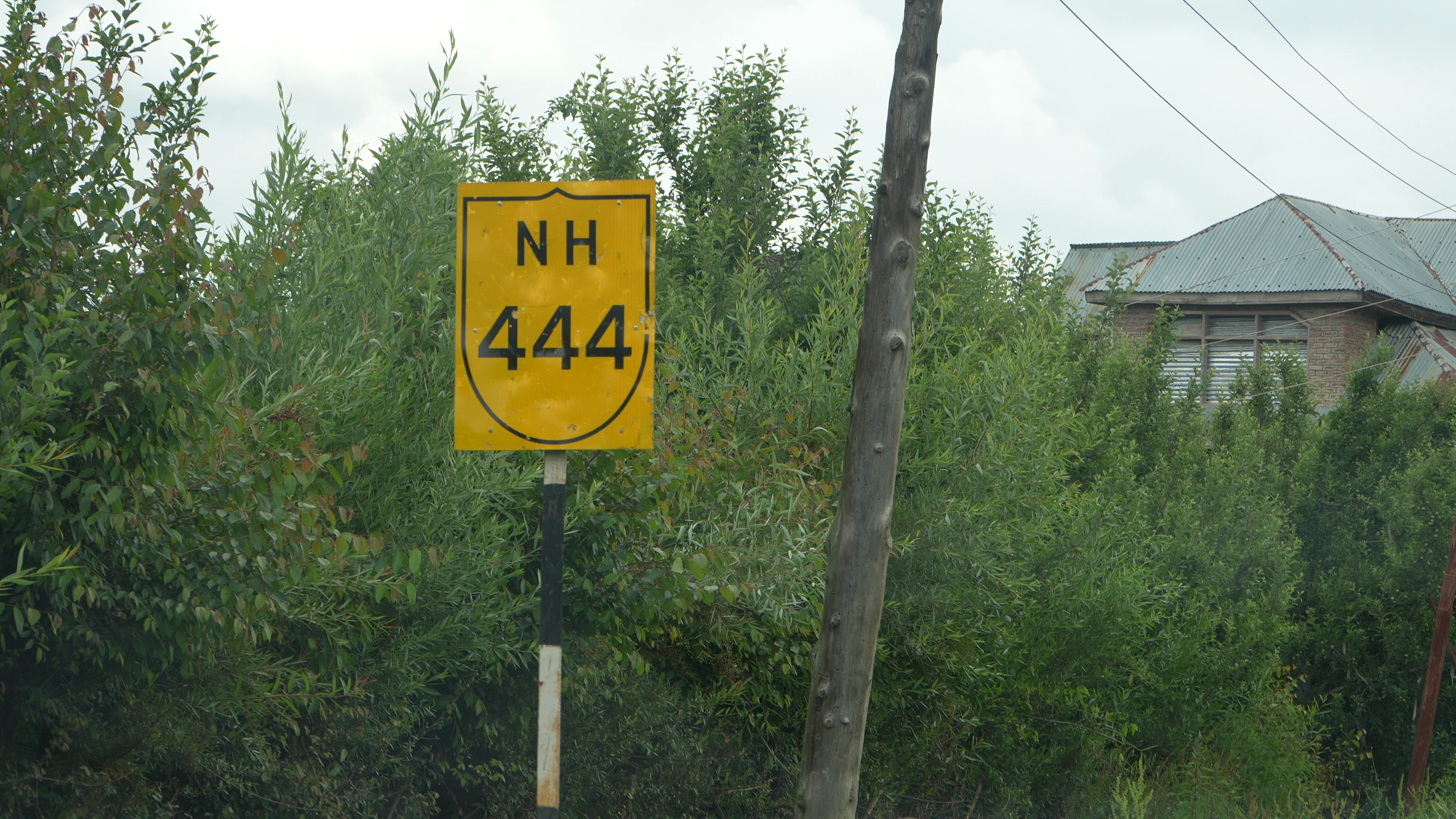
“Did you receive any notice before this was marked for the NH-444 expansion?”
“No,” he said. “Nothing at all.”
He recalled a winter day when a group of men arrived to conduct a survey, drones buzzing above them. When villagers asked questions, they were told the road above the orchards would be widened. Later, officials from the Horticulture Department arrived, explaining that compensation would be paid for the apple trees that would soon be cut. For now, farmers are allowed to continue cultivating their land—this summer may be their last. Around forty households are expected to lose their orchards, often their only source of income. In Nowgam, the road is not yet built. But its presence is already felt—as a line drawn through livelihoods, choices, and a silence shaped by inevitability.
Lines in the Orchard: In Shopian, Farmers Fear a Future Written Without Them
I drove slowly through the apple orchards of Shopian, recording visuals as I tried to grasp the scale of what was unfolding. The road wound through lush green orchards, sleepy hamlets, military installations, and quiet villages, all part of a serene landscape now shadowed by looming development. Somewhere along this route, a road or railway was being planned, its path still uncertain, but its impact already palpable.
Once I reached Shopian town, I met a fellow team member from Kashmir Unheard. He had arranged a visit to Trenz, a village about 10 kilometers away. He dialed a few local farmers to let them know we were coming. We took off along a broken yet beautiful road, shaded by the very orchards that define this region.
Shopian is not just a district, it’s the apple heartland of Kashmir, producing 3 to 3.5 lakh metric tonnes annually. It ranks second in the entire region for apple production, with orchards stretching across 26,231 hectares, according to the Indian Ministry of Agriculture.
As we reached the entrance of Trenz, two men were waiting near a newly constructed car wash station; oddly idle, with no vehicles in sight. They led us to a small office inside the station. Even before we could ask anything, Abdul Rehman, a middle-aged farmer, began speaking. His voice carried urgency.
He recalled the survey conducted in autumn 2024, when news first broke about a railway line, or possibly a station planned through this land. I asked if I could record him, and he nodded, then dialed more farmers whose lands had been surveyed.
The nearest train station is in Qazigund, just 30 minutes away by shared taxi, Abdul said. Shopian town is 10 minutes from here. You can reach any corner of this district in under an hour. Why do we need a railway at the cost of our fields, our trees, our survival?
As we walked through the orchards, the toll of the season was evident. Recent hailstorms had damaged crops, and farmers were bracing for a low yield and even lower income. The weight of uncertainty showed on their faces. Though the buzz around the railway project had died down, the fear had not.
One of the farmers, quiet until now, finally responded to a question I had asked earlier: whether the government had issued any formal notices before the land was marked.
He shook his head.
“No. Just some non-local men came during winter,” he said. “They flew drones over our land, dropped gypsum powder to mark points. That’s all we saw.”
He paused and then added, “Only Allah knows what Modi is planning. But he hates us, that much is clear.”
His words hung heavy in the cold air.
“We won’t let anyone take our land,” he said. “If we stay silent now, it’s not just our orchards we lose, it’s the future of our children. Even if the resistance is difficult, we must keep trying.”
In the quiet groves of Trenz, the apples still hang. But so does a sense that decisions are being made far away, without the consent or even the knowledge of those who stand to lose the most.
These farmers (names withheld) speak at length, recounting what they have witnessed ;the despair, and the growing uncertainty around their land. One of the locals describes the plot he owns as the only inheritance he can pass on to his children, the foundation of his family’s future.
This land is our identity, he says. It sustains us socially, economically, and politically. Losing it would mean losing everything.
For him, and for many others on the brink of dispossession, land is not simply property; it is the core of existence. Around the room, people begin naming one village after another, listing more than a dozen places that stand to be affected.
The group takes me, along with a few colleagues, to the orchards that are soon to be buried under concrete, a stretch of vivid green where apple trees, some nearly forty years old, still stand. I follow them as they guide me deeper into this dense expanse, trying to help me grasp the sheer scale of what is about to disappear.
As we walk, the four men talk among themselves about how the railway project will transform their village.
Modi is on a mission. Maybe next they’ll build cantonments here. If they’re taking our land, they should at least build houses for us. Let them take the whole village.
A middle-aged man, speaks with a sharp edge of anger states.
As I finish recording a long conversation with the men, I am left with a quiet sense of awe at their endurance and clarity. We prepare to leave, and they point out the shortest way back to Shopian – the same broken road we had travelled earlier. After a final exchange of goodbyes, I promise to return.
As part of this work, I developed a practical toolkit for farmers — shared during field workshops to help them understand land acquisition laws, document their land, and assert their rights using Right to Information law.
